We deploy a tracked drill rig and hand auger sets for initial reconnaissance across Rockhampton's steep terrain, particularly around the Athelstane Range and the Berserker escarpment. The local geology, dominated by the Stanwell Formation with interbedded sandstone and mudstone, often produces thin colluvial mantles over weathered rock. Our field crew logs each test pit and core sample systematically, targeting the interface between the residual soil and the underlying bedrock. This interface is where most planar failure surfaces develop after prolonged wet seasons, so we mark every seepage zone and clay seam encountered. The equipment setup includes inclinometer casing for long-term monitoring and piezometers to track pore pressure buildup during heavy rainfall events typical of the region's subtropical climate.
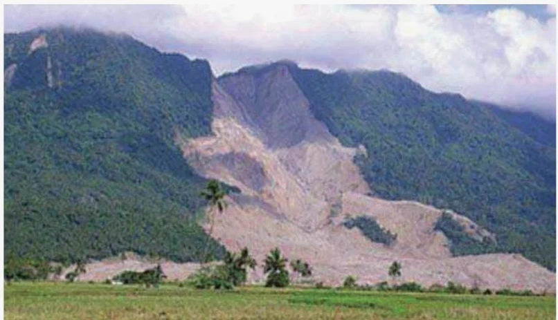
The interface between colluvial mantle and weathered bedrock in Rockhampton's slopes is where most planar failures initiate after heavy monsoon rain.
Scope of work
Area-specific notes
A residential subdivision on the slopes of Mount Archer faced a slow-moving failure surface after three consecutive wet seasons. The original earthworks contractor had benched the slope but did not account for the perched water table within the weathered mudstone. Cracks appeared along the rear boundary wall and the driveway slab tilted 40 mm over six months. Our team installed inclinometers and standpipe piezometers to define the failure geometry. The critical slip surface was located at 6.5 m depth, right at the contact between the colluvium and the intact sandstone. Without a proper landslide assessment, the remedial costs would have exceeded the original site preparation budget by a factor of three.
Standards used
AS 1726:2017 — Geotechnical site investigations, AS 4678:2002 — Earth-retaining structures, AS/NZS 1170.2:2021 — Wind actions (for transient load scenarios)
Linked services
Field Investigation & Instrumentation
Rotary core drilling, test pitting, inclinometer and piezometer installation, with real-time data transmission for remote monitoring of active failure zones.
Stability Analysis & Design
Limit equilibrium and finite element modelling for circular, planar, and wedge failures, including sensitivity analysis for rainfall infiltration scenarios.
Remediation Planning & Supervision
Design of drainage systems, soil nailing, retaining walls, and surface protection measures, followed by construction-phase monitoring and verification testing.
This service complements our laboratory testing work for a complete project analysis.
Typical parameters
FAQ
What triggers landslides in Rockhampton specifically?
The primary triggers are intense rainfall events associated with tropical cyclones and the summer monsoon, combined with the region's expansive clay soils and steep topography. Prolonged wetting reduces effective stress along pre-existing bedding planes in the Stanwell Formation sandstone and mudstone, leading to planar failures at the colluvium–bedrock interface.
How long does a typical landslide assessment take in Rockhampton?
A standard assessment for a single slope — including site reconnaissance, borehole drilling, laboratory testing, stability analysis, and reporting — takes between 20 and 30 business days. Complex sites with multiple failure surfaces or deep seated movements may extend to 45 days, especially during the wet season when access is limited.
What is the difference between a slope stability analysis and a landslide assessment?
A slope stability analysis calculates the Factor of Safety for a given slope geometry and soil parameters, typically using limit equilibrium methods. A landslide assessment goes further: it includes field investigation, identification of existing failure surfaces, pore pressure monitoring, and evaluation of triggering mechanisms such as rainfall infiltration or seismic loading. In Rockhampton, the assessment also addresses the cyclic shrink–swell behaviour of basaltic clays and the risk of progressive failure.
How much does a professional landslide assessment cost in Rockhampton?
The cost typically ranges between AU$1,610 and AU$5,780, depending on the site size, number of boreholes, laboratory tests required, and the complexity of the numerical analysis. A simple single-slope assessment with two boreholes and basic limit equilibrium modelling falls at the lower end, while a multi-slope subdivision with inclinometer monitoring and FEM modelling reaches the upper range.